
Submitted to Stamford’s Harbor Management Commission and Board of Representatives. This page explains the June 2026 proposal; the boundary sketches show concepts for review.
The proposal at a glance
Three steps toward safer shared use
Westcott Cove brings together public beaches, a boat ramp, marinas, waterfront neighborhoods, and Vincent Island. Our proposal responds to concerns raised by people who use and care for these waters.
Mark the rock hazards
Make two charted rocks easier to recognize as the tide covers them.
See the hazards → 02Inform riders at launch
Bring City-reviewed PWC safety information to West Beach Boat Ramp.
Read about signage → 03Define calmer waters
Review an eastward Slow-No-Wake expansion with clear, fixed boundaries.
Explore the expansion →Hazard awareness
Mark what the tide hides
Two rock formations north of Vincent Island are visible at lower tides and become submerged as the water rises. The proposal documents these charted hazards with photographs and location data, and requests appropriate markers at one or both locations.
The requested next steps are Commission support, the CT DEEP marker-permit process, and coordination with the Harbor Master on installation and maintenance. Read the hazard-marker proposal, pages 3–5.
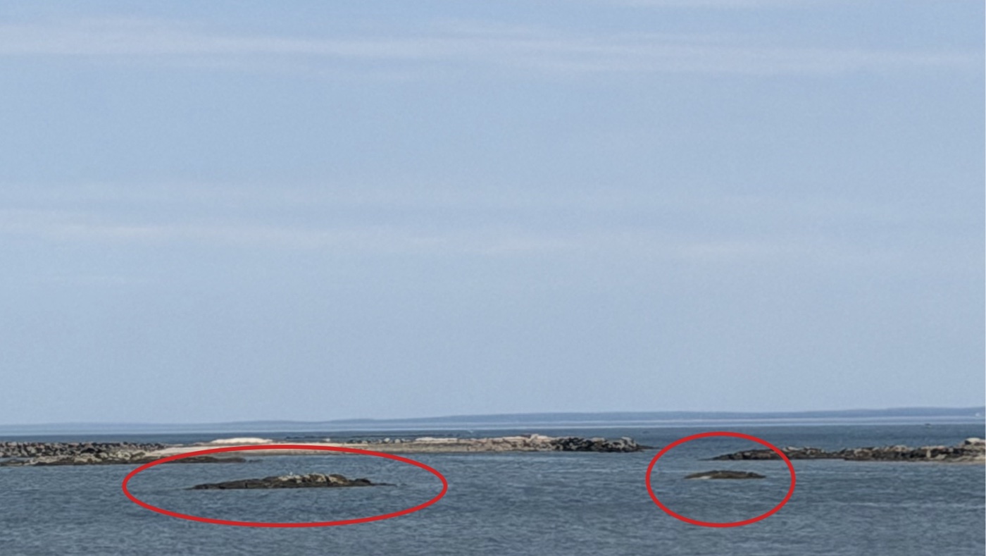

GPS locations of the proposed hazard markers
Rock 1
- Latitude
- 41.037687
- Longitude
- -73.510532
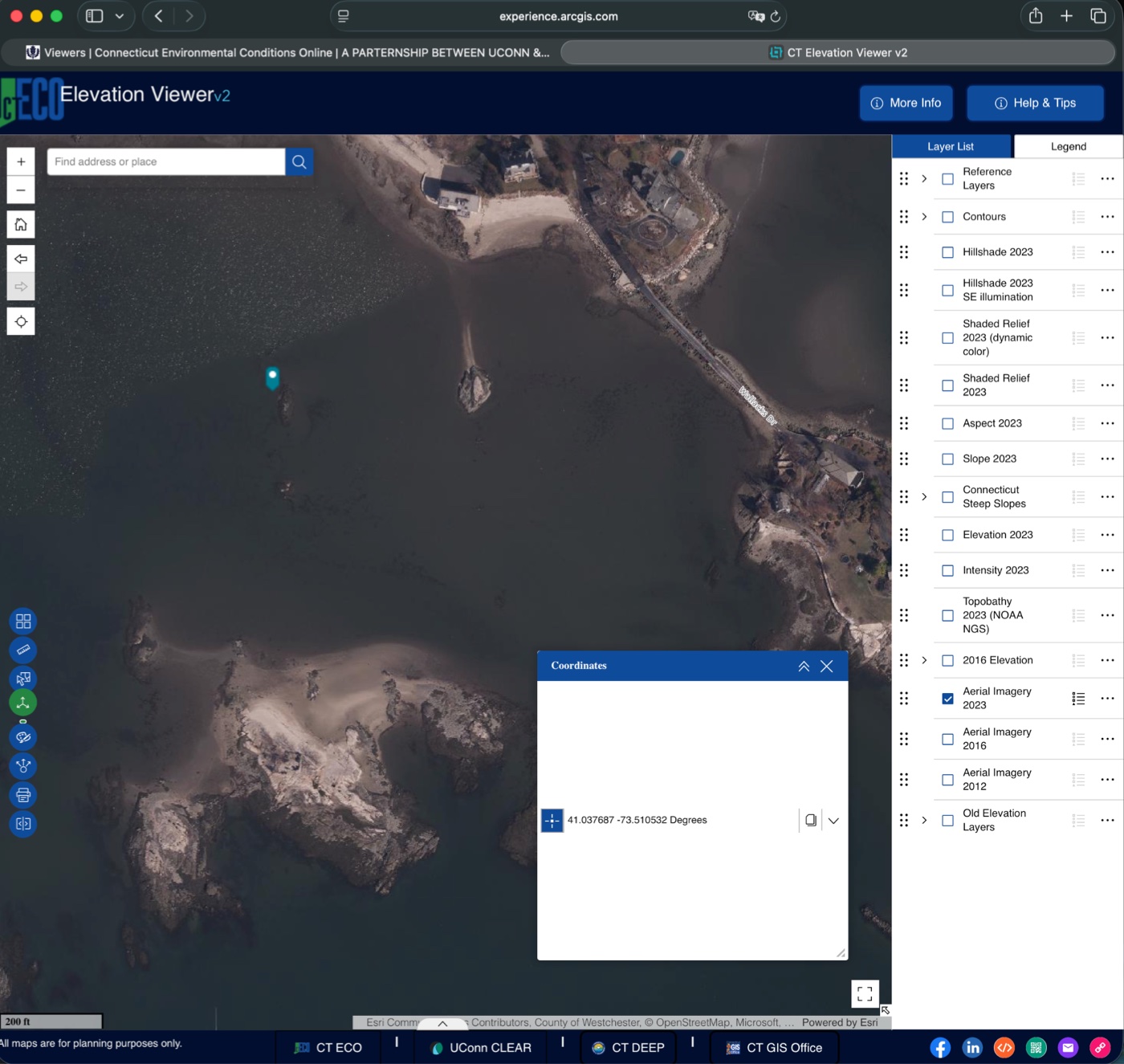
Rock 2
- Latitude
- 41.037221
- Longitude
- -73.510531
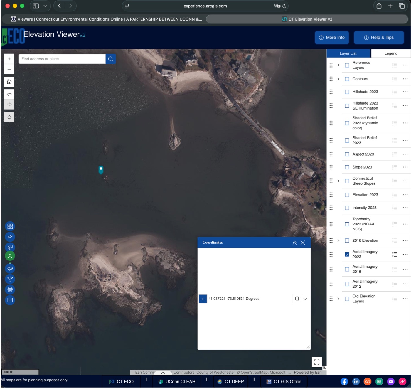
Source: CT ECO ↗. Images and coordinates reproduced from proposal page 3. Select an image to enlarge it.
See the NOAA chart
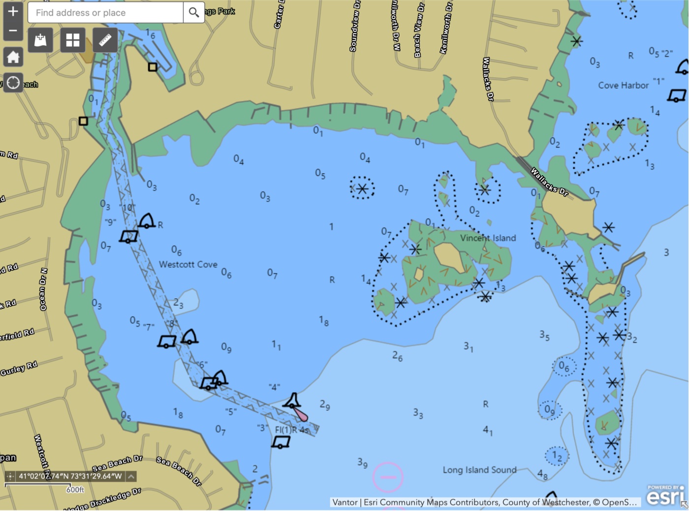
Charted hazards
NOAA chart reproduced on proposal page 4.
These figures document the proposal. Consult current official charts for navigation.
Information before launch
Put local safety information at the ramp
The West Beach launch leads directly into a shallow cove shared with swimmers, kayakers, windsurfers, and small boats. Riders benefit from knowing the local hazards and operating expectations before they reach the water.
The proposal calls for PWC safety signs at West Beach Boat Ramp and Vincent Island, with Harbor Unit review and submission to Stamford Parks and Recreation for public placement.
What the signs would explain
- Personal watercraft operating rules
- Local rock hazards and shallow areas
- Slow-No-Wake zones and a clear local map
Sign content and placement would go through City review.
A clearer boundary
Extend Slow-No-Wake protections eastward
The proposal describes a gap between the cove’s established western Slow-No-Wake area and its busy eastern side. It asks the Commission to review an expansion that gives boaters and the Harbor Unit a clear boundary to recognize, sign, and enforce.
The goal is safer shared use, with more reaction time near swimmers and small craft, less noise, and reduced wake impacts along the shoreline. Our request to PWC riders and all other vessel operators is the same: slow down and keep wakes low so everyone can enjoy the cove safely.

Compare the concepts
Three possible boundaries
The June proposal offers a range from a focused eastern area to full-cove coverage. Select a concept to compare its extent on the interactive map and the original sketch.
A focused eastern expansion
The first sketch adds a defined area around Vincent Island and the eastern shoreline, alongside the existing western zone.
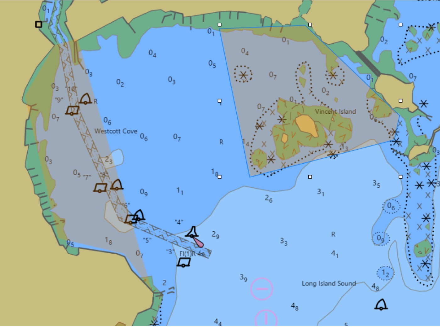
Original proposal sketch
Original sketches from page 8, using a NOAA chart background. Shaded areas illustrate proposed coverage; final boundaries would require official review.
View all three in the original PDF ↗On the water
Footage from the cove
PWC riders are welcome around Vincent Island. These clips illustrate our concern about speed and wake, and our request for every vessel operator to slow down and share the water safely. All four clips are silent and include a written visual description.
Personal watercraft off the beach
A short shoreline view of personal watercraft passing the island and exposed rocks.
- Location
- Westcott Cove, Stamford
Read the visual description
Silent footage filmed across Westcott Cove from the beach. Several personal watercraft travel across the water, leaving visible white wakes near the island and exposed rocks. The camera pans to follow the activity. A person standing on the beach enters the foreground near the end.
Activity across the inner cove
A vertical view follows riders and their wakes across the cove.
- Location
- Westcott Cove, Stamford
Read the visual description
Silent portrait-format footage from the shore. Personal watercraft move across the water near the island and low rocks, leaving wakes behind them. The camera pans across the cove and back toward the island. Beach and shoreline vegetation remain visible in the foreground.
Passing the island and rocks
Personal watercraft move through the waters around the island’s rocky edges.
- Location
- Westcott Cove, Stamford
Read the visual description
Silent landscape footage of personal watercraft moving across Westcott Cove. The camera follows the riders near the island and exposed rock formations. White wakes trail across the water; beach and shoreline vegetation are visible along the bottom of the frame.
A longer look at PWC activity
More than two minutes of riders crossing the cove, with the surrounding shoreline in view.
- Location
- Westcott Cove, Stamford
Read the visual description
Silent footage showing several personal watercraft moving across Westcott Cove and leaving visible wakes. The camera pans between the island, low rocks, and more open water while following the riders. A rock breakwater appears in the foreground. Toward the end, the view widens to include the opposite shoreline and waterfront buildings.
The public conversation
Presented to the community
We presented the proposal to Stamford’s Harbor Management Commission and the Board of Representatives’ Public Safety & Health Committee. The full meeting recordings are available for anyone who would like to follow the discussion.
Explore the evidence
Documents & supporting sources
Westcott Cove Safety Enhancements
The complete submitted proposal, including the cover letter, photographs, charts, three boundary sketches, and references.
Meeting record · PDF
June 25 committee minutes ↗
Public Safety & Health Committee minutes; item PS32.008 records the proposal presentation and an overview of PWC enforcement.
Police report · Facebook
Darien–Stamford marine response ↗
Darien Police describe a joint response with Stamford’s Marine Unit to a capsized vessel. A local example of the rescue work these teams carry out on shared waters.
State guidance
CT DEEP marker permits ↗
Permit information for danger, information, and navigation markers. Relevant to the proposed rock-hazard markers.
State guidance
Connecticut boating certification ↗
CT DEEP information about boating and personal watercraft certificates, for context on the proposed rider-education signs.
Mapping · cited in the proposal
CT ECO map viewers ↗
Connecticut environmental and elevation mapping used to locate the two rock hazards on page 3 of the proposal.
Mapping · cited in the proposal
NOAA nautical charts ↗
The chart source for the cove illustration on page 4 and the background to the boundary sketches on page 8.
City plan · PDF · cited in the proposal
Stamford Comprehensive Plan 2035 ↗
The proposal cites pages 55 and 113 for open-space conservation and Vincent Island’s recreational and wildlife role. Excerpts appear on proposal page 10.
Help shape the next steps
Share your experience of the cove
Do you swim, paddle, boat, or ride here? PWC riders and boaters are part of this conversation. We welcome your observations, ideas, photographs, and videos to help make Westcott Cove safer for everyone who enjoys it.
Email info@vincentisland.com →